


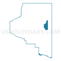
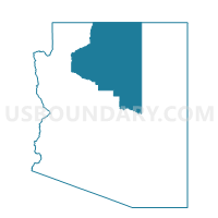
Coalmine Voting District, Coconino County, Arizona
About
Outline

Summary
| Unique Area Identifier | 523734 |
| Name | Coalmine Voting District |
| County | Coconino County |
| State | Arizona |
| Area (square miles) | 294.05 |
| Land Area (square miles) | 294.05 |
| Water Area (square miles) | 0.00 |
| % of Land Area | 100.00 |
| % of Water Area | 0.00 |
| Latitude of the Internal Point | 35.88751100 |
| Longtitude of the Internal Point | -111.09507270 |
Maps

Graphs
Select a template below for downloading or customizing gragh for Coalmine Voting District, Coconino County, Arizona


Neighbors
Neighoring Voting District (by Name) Neighboring Voting District on the Map
- Cameron Voting District, Coconino County, AZ
- Dinnebito Voting District, Coconino County, AZ
- Moenkopi Voting District, Coconino County, AZ
- Pathway Voting District, Coconino County, AZ
- Tolani Lake East Voting District, Coconino County, AZ
- Tolani Lake West Voting District, Coconino County, AZ
- Tonalea South Voting District, Coconino County, AZ